Between 13 and 30 September of 2021 the RITA-2021 intensive measurement campaign took place at and around the Cabauw observatory. The acronym RITA-2021 stands for “Ruisdael Land-Atmosphere Interactions Intensive Trace-gas and Aerosol measurement campaign – Nitrogen and Aerosol Budget Closure experiment” and it involved all major partners of the Ruisdael consortium. Besides the stationary measurement activities at Cabauw the campaign included two additional mobile measurement platforms, being a fully equipped TNO measurement truck for in-situ observations of a suit of trace gases and aerosol characteristics, and the SkyArrow research aircraft (PH-WUR) carrying measurement instrument for air sampling and in-situ greenhouse gas observations. The combined observations of the stationairy Cabauw site and the mobile platforms on the ground and in the air provide an unique opportunity for regional 3D source mapping of GHGs and pollutant trace gas species. The main objective of the RITA-2021 campaign is to improve our understanding of boundary-layer dynamics and cloud formation, the nitrogen budget, and fluxes of GHGs in the ~30×30 km Cabauw footprint combining stationairy and mobile observations and 3 different versions of the high resolution Dutch Atmospheric Large-Eddy Simulation model (DALES).
The main campaign activities included:
The ammonia flux measurement intercomparison experiment at Cabauw involving 3 different novel flux measurement devices.
SkyArrow CO2-flux and in-situ CO2, CH4, N2O, and water vapor observations in the boundary layer and vertical profiles over Cabauw.
The TNO measurement truck for regional source mapping of GHGs and pollutant trace gas species.
The Convective Momentum Transport (CMT) experiment at Cabauw using intensified CMTRACE observations (WindCube, Dual-Freq cloud radar (CLARA), mobile cloud radar (MARA)) to provide observational evidence of CMT.
The aerosol optical column and budget closure experiment combining LIDAR observations, aerosol pre-cursor and composition measurements and detailed meteo at Cabauw.
Impressions of the RITA-2021 campaign:
The SkyArrow research aircraft passing by, and the TNO measurement truck stationed at Cabauw.
The ammonia-flux experiment during RITA-2021 (left panel) and the portable Fourier transformation infrared spectrometer (right panel) to measure the column integrated mixing ratios of the trace gases CO2, CH4 and CO from the spectral absorption of direct sun light. In the background the Sky Arrow research plane starting a vertical profile measurement over the Cabauw site.
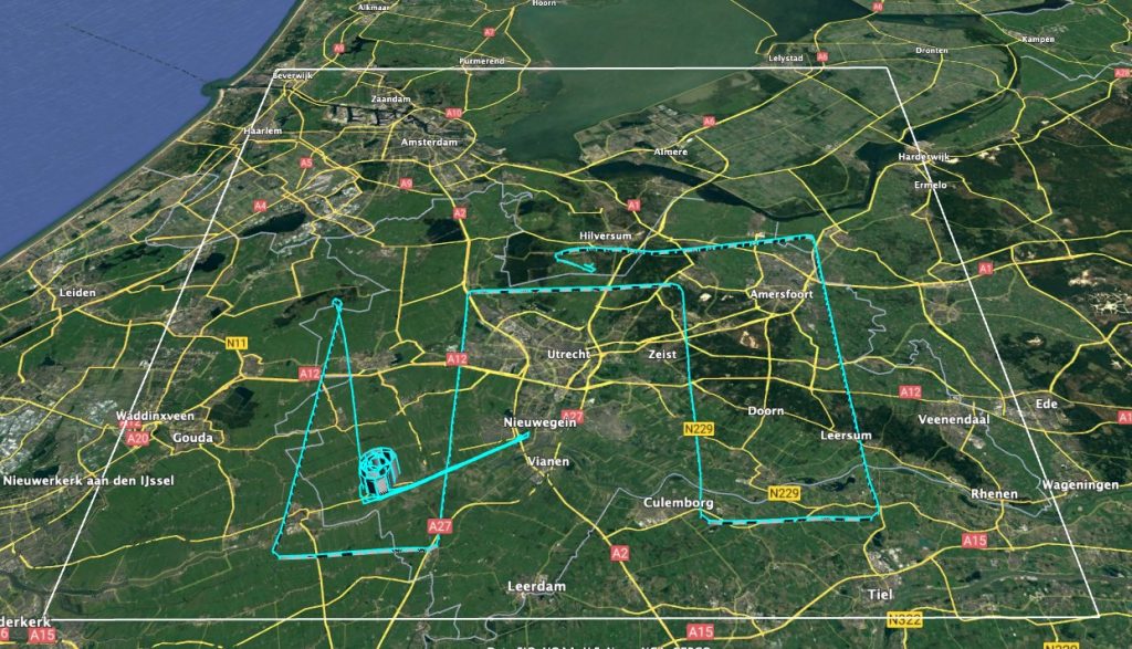
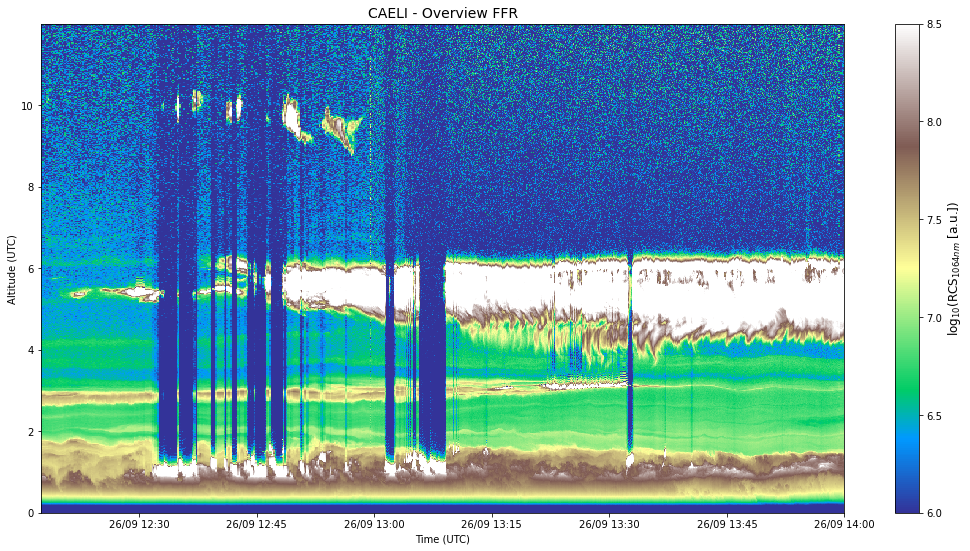
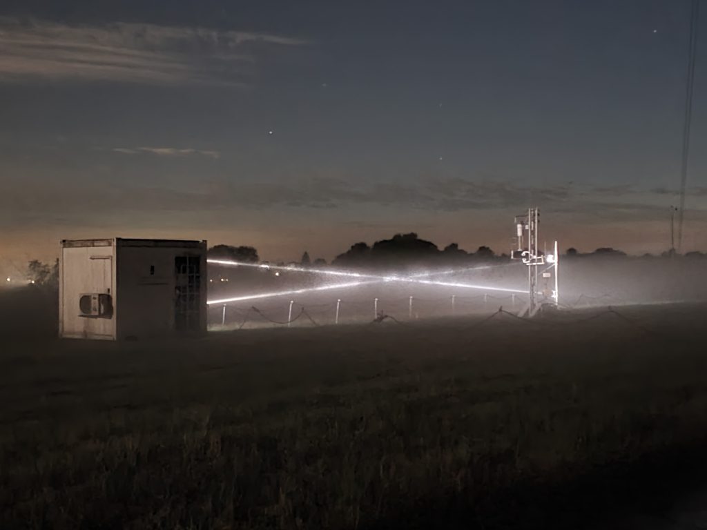
The TNO measurement truck underway (left panel) and from the insight (right panel).Schematic of the RITA-2021 SkyArrow flight track of flight 2 on 14 September 2021 around Cabauw and the city of Utrecht. The white square represents a 50×50 km surface area.On September the 26th the La Palma vulcanic dust plume was detected over Cabauw at an altitude between 5 and 6 km high by the Caeli Raman lidar system stationed at Cabauw (by courtesy of Arnoud Apituley, KNMI). The Caeli system provides continuous day and night high temporal and spatial resolution profiles of aerosol and humidity. Data are available online.Measuring dry deposition of Ammonia with miniDOAS 2.2 at night at the Cabauw site (photo by courtesy of Daan Swart, RIVM).
EM27 FTIR spectrometer total column-averaged dry-air mole fraction of CO2 during the RITA-2021 campaign period (preliminary data by courtesy of Katharina Heimerl, VU).
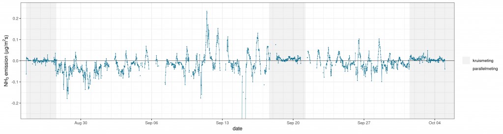
MiniDOAS 2.2 preliminary emission (positive) and deposition (negative) fluxes of NH3 at Cabauw during September 2021 (data by courtesy of Daan Swart, RIVM).
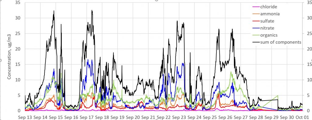
Overview of preliminary Aerosol Chemical Speciation Monitor (ACSM) results showing the anorganic composition of PM2.5 aerosols observed at Cabauw during the RITA-2021 campaign (data by courtesy of Rupert Holzinger, IMAU, Utrecht University).
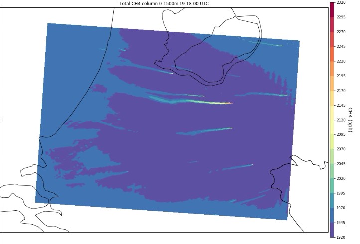
Example of a DALES model high resolution simulation for the area around Cabauw of total column (0-1500 m) integrated CH4 mixing ratios showing individual plumes from point sources such as landfills (image by courtesy of Sander Houweling, VU).
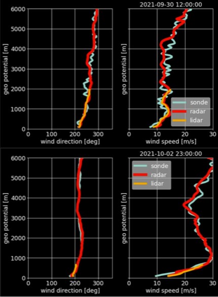
Between September 1 and 30 a total of 34 radiosondes were launched at the KNMI (at 12 and 24 hours) providing vertical profiles of wind direction and wind speed. Even though the KNMI (De Bilt) is 23 km away from the experimental site Cabauw, wind speed and direction profiles from radar and lidar system at Cabauw are very comparable to the radiosonde results (data by courtesy of Louise Nuijens (TUD), and Arnoud Apituley (KNMI)).